


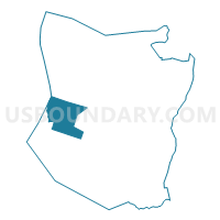
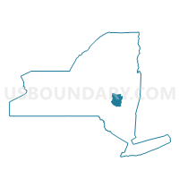
Voting District 150001, Schoharie County, New York
About
Outline

Summary
| Unique Area Identifier | 636702 |
| Name | Voting District 150001 |
| County | Schoharie County |
| State | New York |
| Area (square miles) | 26.53 |
| Land Area (square miles) | 26.14 |
| Water Area (square miles) | 0.38 |
| % of Land Area | 98.56 |
| % of Water Area | 1.44 |
| Latitude of the Internal Point | 42.57632630 |
| Longtitude of the Internal Point | -74.58684150 |
Maps

Graphs
Select a template below for downloading or customizing gragh for Voting District 150001, Schoharie County, New York


Neighbors
Neighoring Voting District (by Name) Neighboring Voting District on the Map
- Voting District 010001, Schoharie County, NY
- Voting District 070001, Schoharie County, NY
- Voting District 090001, Schoharie County, NY
- Voting District 110001, Schoharie County, NY
- Voting District 110002, Schoharie County, NY
- Voting District 150002, Schoharie County, NY
- Voting District 250002, Otsego County, NY
Top 10 Neighboring County Subdivision (by Population) Neighboring County Subdivision on the Map
- Richmondville town, Schoharie County, NY (2,610)
- Worcester town, Otsego County, NY (2,220)
- Fulton town, Schoharie County, NY (1,442)
- Jefferson town, Schoharie County, NY (1,410)
- Summit town, Schoharie County, NY (1,148)
- Blenheim town, Schoharie County, NY (377)
Top 10 Neighboring Unified School District (by Population) Neighboring Unified School District on the Map
- Cobleskill-Richmondville Central School District, NY (14,295)
- Middleburgh Central School District, NY (6,433)
- Charlotte Valley Central School District, NY (3,047)
- Gilboa-Conesville Central School District, NY (2,588)
- Worcester Central School District, NY (2,518)
- Jefferson Central School District, NY (1,871)
Top 10 Neighboring State Legislative District Lower Chamber (by Population) Neighboring State Legislative District Lower Chamber on the Map
Top 10 Neighboring State Legislative District Upper Chamber (by Population) Neighboring State Legislative District Upper Chamber on the Map
Top 10 Neighboring 111th Congressional District (by Population) Neighboring 111th Congressional District on the Map
Top 10 Neighboring Census Tract (by Population) Neighboring Census Tract on the Map
- Census Tract 5907, Otsego County, NY (4,117)
- Census Tract 7405, Schoharie County, NY (3,758)
- Census Tract 7406, Schoharie County, NY (3,229)